
The Department of Geology, Central University of South Bihar Gaya is located in the geologically important terrain of Pre-Cambrian formations to Recent Quaternary deposits. The department of Geology established in 2020 under the School of Earth, Environment and Biological Sciences. Presently Department of Geology offering M.Sc. and Ph.D. Program in Geology. The department is committed to excellence in the creation of new knowledge about Earth, enabling life-long learning by all students about Earth processes to solve the challenges associated with earth dynamics. The fundamental objective of the department to build a young Minds in the field of geology by providing a broad education in all aspects of the geoscience and equip the students with appropriate knowledge and skills to make them employable and capable to serve the Nation. Department has major thrust areasin Water Resources, Geohazards, River Science, Remote Sensing & GIS, Igneous Petrology, Sedimentology,Geochemistry, Geochronology,Palaeontology, Stratigraphy, Geomorphology, Quaternary Geology.
Department Overview
|
Established in |
2020 |
|
Employee Strength |
Faculty- 06 |
|
Student Strength |
Research Scholar & JRF-01 |
|
Placement 2021 |
x (tentative) |
|
Publications, Books & Patent |
Publications- 30 |
News and Announcements
Important Links
-
Formats & Downloads
-
Archive
Board of Studies (BoS)
BoS is a statutory body for each department/centre, primarily responsible for syllabus design and regular update. As described in the Ordinance section 25.10,
The functions of the Board of Studies shall be:-- To recommend to the School Board, courses of studies offered by the Department/Centre and continue updating syllabus;
- To take all steps in accordance with the provisions of the Regulations about teaching and evaluation of various courses/programmes of the Department/Centre;
- To recommend to the School Board measures for the improvement of teaching and research in the Department/Centre;
- To constitute panels of experts to be considered for appointment as Examiners, Board of Examiners for various courses/academic programmes and M.Phil./Ph.D. thesis representing various specializations of Departments/Centres; and
- To perform such other functions as may be assigned to it by the School Board, the Academic Council, the Executive Council and the Vice-Chancellor.
Department Committee (DC)
As enshrined in the Ordinace-26, the Department/Centre Committee (DC/CC) shall consist of the Head of the Department/Centre, as Chairperson ex-officio, and all faculty members of the Department/Centre.
26.2 The Department/Centre Committee shall have the following functions, namely–- To make proposals to the Board of Studies on academic programmes concerning teaching and research, and the creation, specialization and abolition of teaching posts;
- To propose schemes for the maintenance and improvement of the standards of various programmes of study and research of the Department/Centre;
- To apportion the teaching and co-curricular work of the Department/Centre among the teachers thereof and monitor the proper execution thereof;
- To consider and decide on the assignment and utilisation of the space, equipment and other assets of the Department/Centre and other matters of general and academic interest of the Department/Centre;
- To consider and recommend perspectives and major thrust areas for research and to propose research projects to be taken up by the members of the Department/Centre, individually/collectively;
- To review and apprise the SRC/URC with the current status of research in Department/Centre;
- To suggest to SRC/URC norms related to qualifications and research experience of a faculty to be recognized as a research degree supervisor and to constitute Department/Centre Research Degree Committee (DRC/CRC);
- To suggest to University Admission, Teaching and Evaluation Committee (UATEC) on any issue related to admission, teaching, continuous evaluation in courses and students’ assessment of courses, offered by the Department/Centre to improve quality of education.
- To constitute such Committee(s) comprising members of the Department/Centre, and if necessary external experts, for framing and implementation of rules and regulations related to admission, teaching, continuous evaluation, maintenance of students’ records including alumni affairs as well as promotion of research and development; and
- To perform such other functions as may be assigned by the Ordinances or Regulations, or by the Vice- Chancellor/Dean/School Board from time to time.
Department Research Degree Committee (DRDC)
Departmental/Centre Research Degree Committee (DRDC/CRDC) deal with all matters connected with the Ph.D. Programme of the Department and report the matter to the University Research Degree Committee (URDC), as per University Ordinance-33. It consists of the Head of Department/Centre as Chairman and other faculties in the department.
Functions of DRDC/CRDC are as follows:- Allotment of Supervisor, Co-Supervisor, recording reasons for not admitting a candidate.
- Recommendation for extension of time for submission of thesis
- Recommendation to peruse a part of research outside the University
- Approval of the Course Work
- Assessment and Grading in Course Work
- Monitoring the research progress of the candidate
- Approval of Research plan proposal/language
- Sanction of duty leave to the Ph.D. candidate
- Assessment of Ph.D. work through pre-submission seminar
- Maintaining the record of research paper publications of the candidate
- 11 Recommendation of panel of experts for thesis evaluation
- Assessment of revised thesis for satisfactory compliance, if any
- Arrangement of Viva-voce in the absence of the supervisor
- Recommendation to waive the Viva-voce
Research Advisory Committee (RAC)
A Research Advisory Committee (RAC) is constituted for every research scholar admitted in PhD programme. The Committee would guide the research scholar to develop the study design and methodology of research and to To periodically review and assist in the progress of the research work of the research scholar. The committee shall have also have power to recommend the co-supervisor and cancellation of registration
Vision |
|
Mission |
|
- To enhance scientific skills and promote research and development activities.
- To impart knowledge and hands-on exercises related to various applied
- disciplines of geology having great societal impact.
- To train the students to join various premier public and private organizations related to geology and natural resources management.
- To acquire knowledge about exploration and exploitation of earth resources in a sustainable manner and support the SDGs.
- To carry out Geological field work/training in various applied field to develop the practical skills for evaluation and mapping of important earth resources.
- To train the students for project management and independent work for supporting the start-up and capacity building skills
- To impart knowledge of Geology with special emphasis on various applied aspects of geology.
- To produce skilled manpower with applied aspects of Geology employable for positions in the field of education, industry and government and non-government organizations.
- To enhance knowledge of geological science with more recent tools and techniques.
- To develop project management skills via post-graduation dissertation on different applied aspects of geology.
- To impart the basic understanding of the various societal issues and the role of Geologist to provide the solution.
- To promote comprehensive and interdisciplinary knowledge in both teaching and research by emphasizing inter-linking of geology with other branches of Science and Engineering.
Program: M.Sc. Geology
Eligibility:
Bachelor's degree in Geology from any recognized University with a minimum of 55% marks for General / OBC candidates and 50% marks for SC/ST/PWD candidates.
Intake: 45
Program Objectives
Program Outcome
- Objectives of the Program:
- To motivate the students to conduct research in close relation to sustainable development of earth resources and its management.
- To encourage the students to conduct multi-disciplinary research in the field of Geology.
- To provide research and educational opportunities in solving complex problems related to Earth Sciences for societal benefit.
b. Program Outcomes:
- Ensure capability to perform research by applying scientific research methodology and place the results in a broader context
- Develop a research-ethical attitude.
- Ensure capacity to conceive, adapt and develop an independent investigation that meet the requirements embraced by international academic standards;
- To develop the capacity to communicate the results of research work to other geologists, academic community and society
- Development of skills for self-learning, practical application of theoretical knowledge, work on interdisciplinary problems.
c. Eligibility:
M.Sc. or MSc (tech)in Geology, M. Tech. Applied Geology & M.Sc./ M.Tech. in Remote Sensing and Geospatial Technology, P.G. pertaining inter- & intra-disciplinary subject with 55% in aggregate or its equivalent Grade B in UGC 7-point scale. A relaxation of 5% of marks from 55 to 50% or equivalent relaxation of Grade for SC/ST/OBC(Non creamy layer)/Differently abled candidates.


- Lab facility
- Research labs
Facilities Available in Geology Laboratory (1)
|
S.No. |
Name of Lab Infrastructure/ Instruments/ Tools
|
Availability in numbers
|
|
1) |
Work Station with storage drawers, stands and Chairs
|
50 |
|
2) |
Wall Cabinets
|
33 |
|
3) |
Fume hood
|
01 |
|
4) |
Petrological Microscope |
25 |
|
5) |
Stereo-zoom Microscope
|
25 |
|
6) |
Hardness Box
|
05 |
|
7) |
Structure Geology Model |
27 |
|
8) |
Laboratory Oven |
01 |
|
9) |
Hot Plates |
02 |
|
10) |
Microfossils Preparation Kit Micro-faunal slides (various), Sorting trays, Aluminium Tray, Picking brush 000 (Nylon), Metallic Needle holder adjustable, Standard Test Sieves: made of brass frame of dia. 4”, Slides Cabinet & Enamel Bowl 16 cm dia. |
275+ 25+ 05 +25 +05 +01 set + 01 set +05 |
|
11) |
Minerals and Rocks (all type) thin sections |
184 |
|
12) |
Macro- Mega Fossils cleaning equipment Compressor with nozzles, Pots and Pans, Water Cooker, Table Lamps, sand-bag |
|
Surveying Instruments
|
S.No. |
Instrument Name
|
Availability in numbers
|
|
1) |
Total Station |
02 |
|
2) |
Plain Table |
02 |
|
3) |
Dumpy Level |
02 |
|
4) |
Theodolite |
02 |
Available Field Equipments
|
S.No. |
Equipment Name |
Availability in numbers
|
|
1) |
Clinometer compass |
10+ |
|
2) |
Brunton Compass |
50+ |
|
3) |
Hand Lens, |
52+ |
|
4) |
Geological Hammer (Estwing) |
49 |
|
5) |
Chisel (Estwing) |
04 |
|
6) |
Penknife |
10 |
|
7) |
Bar Magnet (small) |
06 |
|
8) |
sample bags |
50 |
|
9) |
Satchel |
|
Facilities Available in Geology Laboratory (2)
Remote Sensing and GIS Laboratory
|
S.No. |
Numbers of PC |
Available Softwares |
|
1 |
26 |
Ø ArcGIS (25 Licences) Ø Erdas Imagine (15 Licences) Ø Geomedia (15 Licences) Ø Leica Photogrammetry (15 Licences) Ø Q-GIS (15 Licences) Ø Corel Draw (01Licence)
|
- Remote Sensing & GIS and Groundwater Modelling
- Sedimentology and Paleontology
- Geohazard Mapping & Mitigation Lab
- Geomorphology and Hydrology
- Advance Surveying Lab
Major Thrust Areas of Research
- Groundwater Hydrology and Aquifer Modeling
- Natural Hazards (Landslide & Flood)
- Groundwater Quality and Urban Geology
- Remote Sensing & GIS applications in Earth Sciences,
- Biostratigraphy, Palaeobiogeography, Palaeoclimate, Vertebrate Palaeontology and Micropaleontology.
- Sedimentology, Sediment Provenance Study, Geochemistry, Geochronology, Fission Track Dating.
- Quaternary Geology, Cryosphere and climate change effect on natural resources and environment.
Research Publications
- Singh, R.P., Mahajan, M., Gandhi, K. Prafull Singh (2023) A holistic review on trend, occurrence, factors affecting pesticide concentration, and ecological risk assessment. Environ Monit Assess 195, 451 (2023). https://doi.org/10.1007/s10661-023-11005-2 (IF 3.307)
- .Srivastava A, Shukla S, Singh Prafull, Jha PK. (2023) Spatio-temporal dynamics of land use/cover and land surface temperature in Prayagraj city, India. Indoor and Built Environment. doi:10.1177/1420326X231159633 (IF. 3.067)
- Prafull Singh, S Chaudhuri, Pradipika Verma and Vivek Singh (2022). Earth Observation data sets in Monitoring of Urbanization and Urban Heat Island of Delhi, India. Geomatics, Natural Hazards and Risk. 13:1, 1762-1779, DOI: 10.1080/19475705.2022.2097452 (IF. 3.922)
- Sur, U., Prafull Singh, Meena, S.R.; Singh, T.N. (2022) Predicting Landslides Susceptible Zones in the Lesser Himalayas by Ensemble of Per Pixel and Object-Based Models. Remote Sens. 2022, 14, 1953. https://doi.org/10.3390/rs14081953 (IF. 5.349)
- Aman Kakkar, P. K. Rai, V. N. Mishra, Prafull Singh (2022) Decadal trend analysis of rainfall patterns of past 115 years & its impact on Sikkim, India, Remote Sensing Applications: Society and Environment, https://doi.org/10.1016/j.rsase.2022.100738.
- K.Singh, Prafull Singh, Martin Drews (2021) A machine learning-based classification of LANDSAT images to map land use and land cover of India. Remote Sensing Applications: Society and Environment. https://doi.org/10.1016/j.rsase.2021.100624
- S. Prajapatia , P. K. Rai , V.N. Mishra , Prafull Singh (2021) Remote sensing-based assessment of waterlogging and soil salinity: A case study from Kerala, India. Results in Geophysical Sciences. https://doi.org/10.1016/j.ringps.2021.100024
- Anindita Sarkar Chaudhuri, Prafull Singh, Pradipika verma3 S. C. Rai (2021) Computation of Groundwater Recharge prospect in urban environment for sustainable water security. Arabian Journal of Geoscience. 14:606, https://doi.org/10.1007/s12517-021-06904-y (IF-1.827).
- Ujjwal Sur and Prafull Singh (2021) Landslide probability mapping by considering fuzzy numerical risk factor (FNRF) and landscape change for road corridor of Uttarakhand, India. Environment, Development and Sustainability https://doi.org/10.1007/s10668-021-01226-1 (IF: 3.219).
- Ujjwal Sur and Prafull Singh, Sansar Raj Meena (2020) Landslide Susceptibility Assessment in a Lesser Himalayan Road Corridor (India) applying Fuzzy AHP technique and Earth-Observation data. Geomatics, Natural Hazards and Risk. 2020, VOL. 11, NO. 01, 2176–2209 (IF: 3.333).https://doi.org/10.1080/19475705.2020.1836038 .
- Prafull Singh, Ankit Sharma, Ujjwal Sur, P.K.Rai (2020) Comparative landslide susceptibility assessment using statistical information value and index of entropy model in Bhanupali-Beri region, Himachal Pradesh, India. Environment, Development and Sustainability DOI: 1007/s10668-020-00811-0 (IF: 4.080).
- Ujjwal Sur and Prafull Singh (2020) assessment of landscape change of lesser Himalayan road corridor of Uttarakhand, India. Journal of Landscape Ecology. 13,1-22
- Singh Prafull (2023) Groundwater Potential Assessment Using GIS-Based Weighted Linear Combination Technique: A Case Study of Hard Rock Terrain Around Bhopal, India. Impacts of Urbanization on Hydrological Systems in India , ISBN978-3-031-21617-6 : DOI10.1007/978-3-031-21618-3
- Singh Prafull (2023) Remote sensing-based study of landslide hazard zonation in Namchi and its surrounding area of Sikkim, India. doi.org/10.1016/B978-0-323-99262-6.00013-4. Atmosphric Remote sensing . Principles and Applications. ISBN: 978-0-323-99262-6
- Singh, R.K., Das, A.K., Jain, H., Singh, P., Kumar, P. (2022). Mapping and Identification of Trees Using Semantic Segmentation Deep Learning Neural Network. In: Kumar, M., Dhyani, S., Kalra, N. (eds) Forest Dynamics and Conservation. Springer, Singapore. https://doi.org/10.1007/978-981-19-0071-6_18
- Mishra, V.N., Prasad, R., Rai, P.K., Nistor, MM., Singh, P. (2022). Using Remote Sensing Technique to Investigate Land Use/ Land Cover Changes in Varanasi District (UP), India. In: Singh, R.B., Kumar, M., Tripathi, D.K. (eds) Remote Sensing and Geographic Information Systems for Policy Decision Support. Advances in Geographical and Environmental Sciences. Springer, Singapore. https://doi.org/10.1007/978-981-16-7731-1_21
- Deepak Choudhary, Advait M. Jukar, Rajeev Patnaik, Nongmaithem Amardas Singh, Ningthoujam Premjit Singh, and K. Milankumar Sharma 2023 (Accepted; in press). The first report of Zygolophodon (Mammalia, Proboscidea, Mammutidae) from the late Miocene of Kutch, India. Journal of Vertebrate Paleontology. https://doi.org/10.1080/02724634.2023.2197959 IF.2.558
- Priyananda Singh, K. Milankumar Sharma (corresponding author), Raghavendra Prasad Tiwari1, Rajeev Patnaik, Nongmaithem Amardas Singh and Ningthoujam Premjit Singh, 2023. Lepidosauromorphs and associated vertebrate fauna from the Late Triassic Tiki Formation, South Rewa, Gondwana basin, India: implication for paleoenvironment and paleobiogeography. Proceedings of the Indian National Science Academy. DOI: 10.1007/s43538-023-00162-0 , IF- 0.57 (Scopus & SCI).
- Priyananda Singh, Kingson Oinam, K. Milankumar Sharma (corresponding author), et al. 2022. Evolution of the Permo-Triassic Satpura Gondwana Basin, Madhya Pradesh, India: Insights from geochemical provenance and palaeoclimate of the siliciclastic sediments. Geological Journal. https://doi.org/10.1002/gj.4619 IF: 2.12 (Scopus & SCI).
- Nongmaithem Amardas Singh, Ningthoujam Premjit Singh, Milankumar Sharma (corresponding author), Rajeev Patnaik, R.P. Tiwari, Ramesh Kumar Sehgal, Vinay Kumar, Wasim Abass Wazir, Y. Priyananda Singh and Deepak Choudhar, 2022. First report on late Miocene (Tortonian: ~11-10 Ma) charophyte gyrogonites from Tapar, Kachchh District, Gujarat State, western India. Proceedings of the Indian National Science Academy 88(1), DOI: 10.1007/s43538-022-00102-4 . IF- 0.57 (Scopus & SCI).
- Nongmaithem Amardas Singh, Deepak Choudhari, Y. Priyananda Singh, Ningthoujam Premjit Singh, Rajeev Patnaik, R.P. Tiwari and Milankumar Sharma*(corresponding author) 2022. Chondrichthyan and osteichthyan fauna from the middle Miocene deposits of Palasava, Kutch, India: implication for paleoenvironment and paleobiogeography. Comptes Renduz Pelevol. 21(43): 939-968. IF- 2.326 (Scopus & SCI).
- R Khan, Indhulekha K, Y K Mawale, Rakesh Dewangan, Shubhedu Shekhar, C S Dwivedi Vikal K Singh and D C Jhariya (2020) Impact of anthropogenic activities on groundwater quality and quantity in Raipur City, Chhattisgarh, India., IN: National Conference on Challenges in Groundwater Development and Management, IOP Publishing, IOP Conf. Series: Earth and Environmental Science 597, 1-9, 012006, doi:10.1088/1755-1315/597/1/012006. (Impact Factor: 0.4)
- C. Jhariya; Rubia Khan; K. C. Mondal; Tarun Kumar; Indhulekha K.; Vikal K. Singh, (2021) "Assessment of Groundwater Potential Zone Using GIS-based Multi-Influencing Factor (MIF), Multi-Criteria Decision Analysis (MCDA) and Electrical Resistivity Survey Techniques in Raipur city, Chhattisgarh, India". Journal of Water Supply: Research and Technology-Aqua, 70 (3), 375–400, ISSN - 2709-8028, https://doi.org/10.2166/aqua.2021.129. (Impact Factor: 3.007). Cite Score - 4.1
- Singh, A.K., Dubey C.S., Singh D.S., Kumar, D., Sharma, R. “Sedimentary Parameters and Evolution of the Outwash Plain deposits during late Holocene in the Gangotri Glacier Region, Garhwal Himalaya, India”.
Journal of the Geological Society of India (In Press) (IF-466) - Gautam, P.K., Kumar, D., Singh, A.K., Singh D.S. “Drainage Network Analysis and Tectonics Interference of the Reth River, Central Ganga Plain (India) Using Geospatial Technology”. Geotectonics (In Press) (IF-142)
- Singh, A.K.., Kumar, D., Dubey, C.A.., Gautam, P.K., Vishawakarma, B., Singh, D.S. Glacial Morpho-Sedimentology and Processes of Landscape Evolution in Gangotri Glacier Area, Garhwal Himalaya, India. Climate Change and Geodynamics in Polar Regions, Taylor & Francis DOI: 10.1201/9781003284413-9
- Authored / Edited Books
- P.K.Rai, Prafull Singh, V.N.Mishra (2022) Geospatial Technology for Landscape and Environmental management – Sustainable Assessment and Planning. Publisher Springer Nature Switzerland. ISBN: 978-981-16-7373-3. https://link.springer.com/book/10.1007/978-981-16-7373-3
- P.K.Rai, Prafull Singh, V.N.Mishra (2021) Recent Technologies for Disaster Management and Risk Reduction -Sustainable Community Resilience & Responses. Publisher Springer Nature Switzerland. ISBN.978-3-030-76116-5. https://link.springer.com/book/10.1007/978-3-030-76116-5
- V.N.Mishra, P.K.Rai, Prafull Singh (2021) Geo-information Technology in Earth Resources Monitoring and Management. Nova Science Publishers (U.S.A.). ISBN:978-1-53619-796-9. https://novapublishers.com/shop/geo-information-technology-in-earth-resources-monitoring-and-management
E-Resources for Courses
|
Course Code |
Course Name |
Question papers (Previous Years) |
Notes and Presentations |
Video and Suggested readings |
Course Assessment Design - MSc
- Semester –I
- Semester –II
- Semester –III
- Semester-IV
Gallery
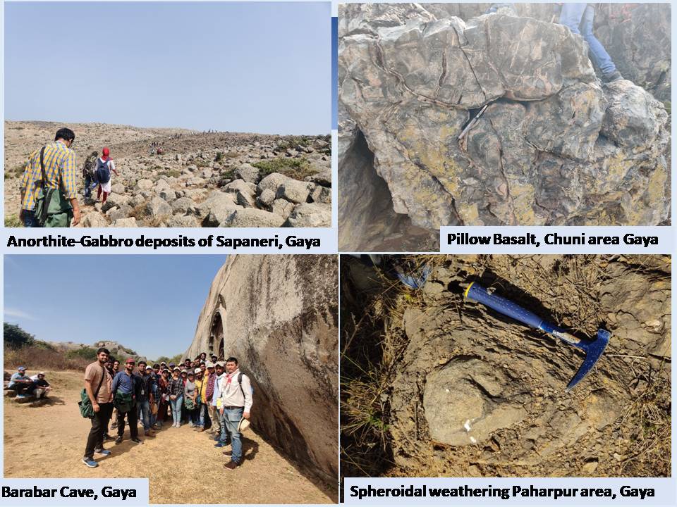

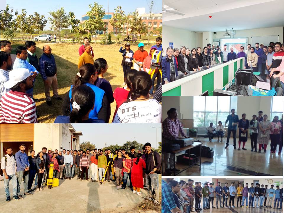

Department Of Geology
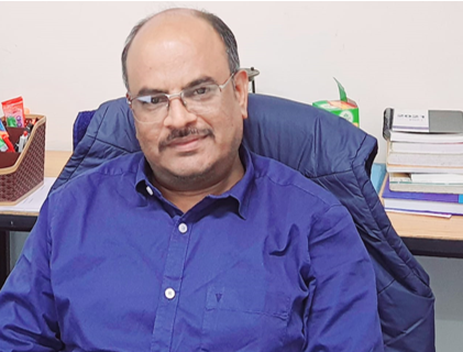
- Present Head
| HOD Name | Period | Contact | Image |
|---|---|---|---|
| Prof.(Dr.) Prafull Kumar Singh | 03.08.2022-Onwards | Contact : 0631-2229- Email : prafullsingh@cusb.ac.in |
 |
- Former Heads
- Dr. Prafull Kumar Singh Period: 01.02.2022 to 02.08.2022
- Prof. (Dr.) Dhirendra Kumar Pandey Period: 05.06.2020 to 31.01.2022
| Office Staff/ Lab Staff | Email Id | Contact | Image |
|---|---|---|---|
| Albinus Topno (LDC) | albinus@cub.ac.in | 0631-2225-000 |  |